
A Blueprint for Safer, Quieter Streets in NYC
Why NYC needs to go beyond Open Streets and pilot permanent low-traffic zones that prioritize pedestrians over cars - and how DOT can get it done

In 2024, there were 266 deaths and 54,137 injuries in NYC due to car crashes, with over half of those killed being cyclists or pedestrians. Every day on streets like Canal Street, parents weave with their kids through honking traffic on their way to school while cyclists and delivery vans and residents must contend with thru traffic clogging the roads.
Meanwhile, since 2014, NYC has been committed to reducing the death toll from car crashes through its Vision Zero initiative, and NYC Department of Transportation (DOT) Commissioner Ydanis Rodriguez has pledged to make NYC the most walkable and bikeable city in the nation. To finally achieve these goals, and results by which NYC DOT is directed to pursue in its Streets Plan1, DOT should implement Low Traffic Neighborhoods (LTNs) that redesign NYC’s streets to be more pedestrian-friendly by rerouting thru traffic vehicles off of residential streets. For the City to truly achieve Vision Zero, NYC must progress from temporary open streets programming and unprotected bike lanes to permanent Low Traffic Neighborhood structural redesign.
How Do LTNs Work?
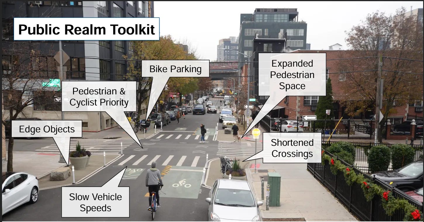
LTNs are groups of residential blocks redesigned so cars can access local roads but not drive straight through, cutting down on dangerous shortcuts. Tools like pedestrian plazas, protected bike lanes, and curb extensions are utilized to slow passing cars and protect pedestrians. Conveniently, LTNs also combine many of the already existing and underway efforts across the City: expanding bike lanes and busways, Open Streets, and planting more trees on the streets. LTNs are the logical next step that synchronize these currently disconnected efforts to maximize their impact in protecting residents from vehicles and improving mobility for all forms of transportation.
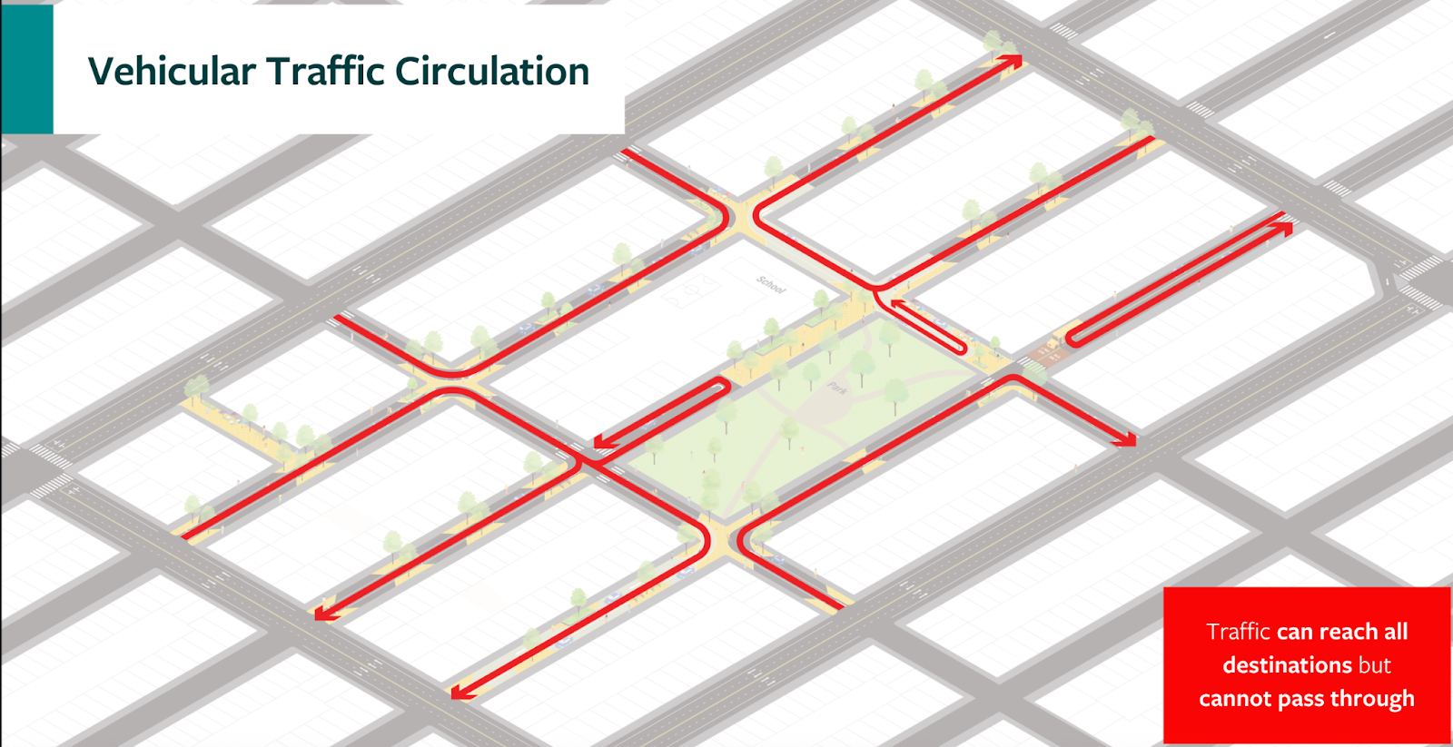
Low Traffic Neighborhoods achieve less traffic (even on the boundary roads they funnel cars towards) and fewer casualties simultaneously by redesigning residential streets using proven urban planning principles. The strategic arrangement of local roads allows for flexibility in each neighborhood’s LTN design by removing dangerous through-traffic while prioritizing residents’ needs. Streets in front of schools or bordering parks can be converted into pedestrian-only plazas full of residential amenities like green spaces and sidewalk cafes, while other roads can be converted into low-speed one-way streets that provide residents safe and traffic-free access to major roads.
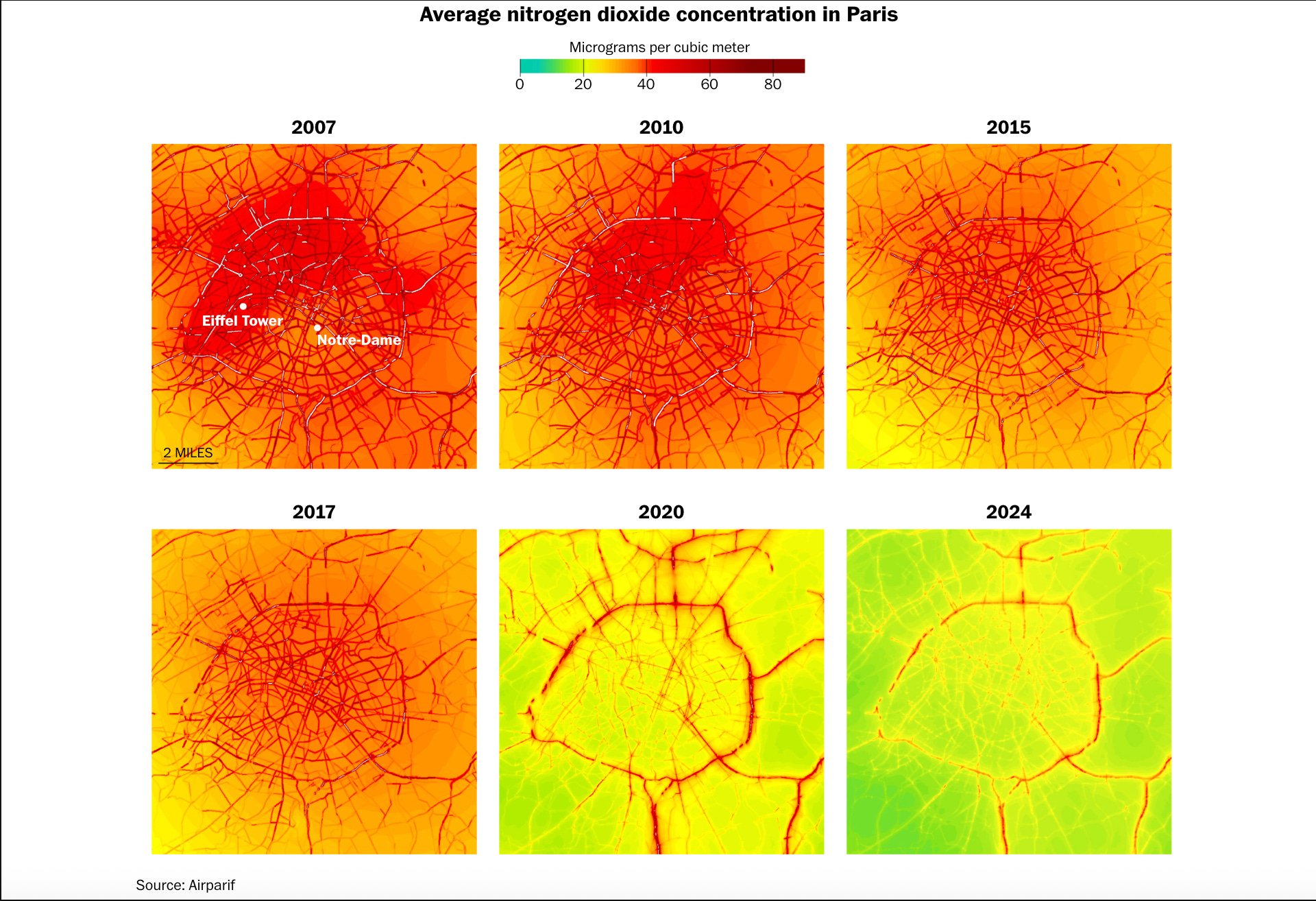
According to Open Plans, previous LTNs have resulted in a 46.9% drop in overall traffic volume and a 1.6% decrease on boundary roads. They have led to 50% reduction in car-related casualties, 10-18% reduction in crime, 5.7% decrease in concentration of nitrogen dioxide, and 25% more active travel. In London, LTNs prevented 37 deaths and half a million sick days annually. The return to NYC for developing its own LTNs citywide is multiple times the one-time development costs, both in terms of financial savings from reduced need for emergency and healthcare services and in improved quality of life for residents.
Establishing permanent LTNs provides the greatest potential for pedestrian safety and permanent improvement in residential livability while capitalizing on cost efficient solutions and lower administrative overhead in the long term.2
LTNs Are Popular and Feasible
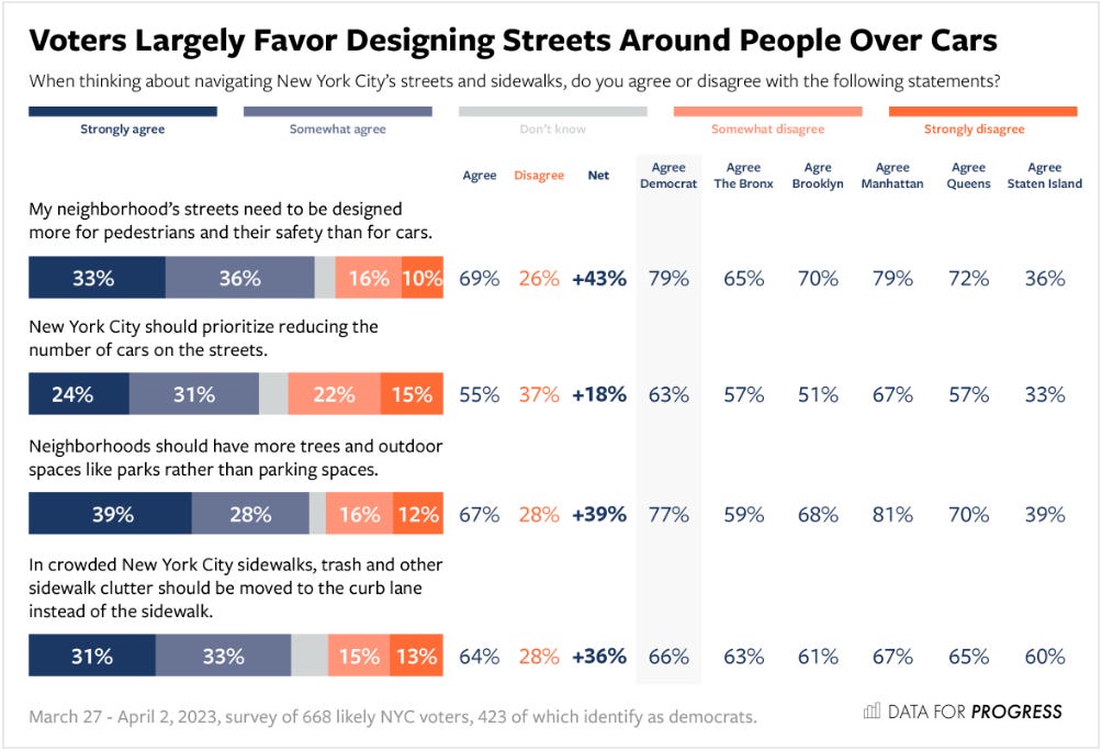
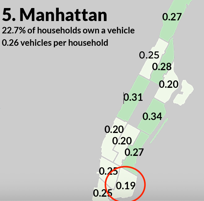
As a sponsoring agency of Vision Zero, DOT has been committed for over a decade to reaching zero vehicle-related fatalities in NYC, a goal it has yet to achieve. Meanwhile, less than half of NYC households and fewer than a quarter of households in Manhattan own a car - suggesting that out-of-towners benefit while residents pay the costs. Redesigning these residential streets to become narrower one-ways with expanded pedestrian sidewalks or car-free pedestrian plazas would reduce traffic and traffic-related casualties for residents while improving the air quality, noise quality, and overall quality of life for all who reside in the LTNs. There is no reason that millions of New Yorkers should breathe exhaust and dodge traffic for the convenience of a minority of car-owners.
While redesigning streets presents higher upfront costs, the post-construction administrative burden of this policy is negligible and the ability to customize street configurations for every neighborhood provides maximal equity. In many cases, streets can be redesigned in cost-effective manners, utilizing paint on the ground and cheap flexposts to re-route traffic. Planters and trees can also be utilized to divide cars from bikes and pedestrians in a manner that simultaneously beautifies the streets and provides shade.
Preserving one-way and limited access roadways maintains equitable access for disabled persons and emergency vehicles. Smart design can enable residents to maintain their access to roads while thru-traffic and longer car journeys are incentivized to use major boundary roads outside the LTNs. Thus LTNs would satisfy residents’ demands for safer streets without sacrificing access to roads where necessary.
Community input can further inform street redesign and ensure elements incorporated into the new street match neighborhood characteristics. The redesign process would be similar to DOT’s existing procedure of conducting public surveys, running workshops in the potentially affected areas, and collaborating with community boards and local organizations to iterate on initial proposals.
How LTNs Capitalize on DOT’s Existing Policies
NYC has shown the feasibility of reversing car-centric street design through recent policies such as the Congestion Relief Zone, the Open Streets program, and expanding bike lanes across the City. However, traffic fatalities remain in the hundreds each year and vehicles continue to pollute the air and ears of residents. With the rise of wayfinding apps like Google Maps, cars have also increasingly used residential streets to reach their destinations. This leads to smaller roads becoming clogged with thru traffic while kids are exiting school, families walking their neighborhoods, and cyclists and pedestrians all vying for already limited road space.
The recently established and now permanent yet dwindling Open Streets program presents one of DOT’s best efforts to date to pedestrianize NYC’s streets. The program involves partnering with local organizations to create an “open street” where barricades and volunteers coordinate to close a road to non-emergency traffic for pre-specified days and times throughout the year. Open Streets are quick and easy to implement, requiring no more infrastructure than temporary barricades and relying on community volunteers for enforcement. However, such reliance on volunteers has resulted in many Open Streets being inconsistently maintained or completely non-operational, and results in equity issues where neighborhoods with fewer resources are less likely to have open streets. Even when properly maintained, open streets are temporary solutions with limited vehicular closures, and their lack of connectivity to each other limits their overall impact on walkability and safety citywide.
DOT has also launched anti-reckless driving initiatives, such as the educational Dangerous Vehicle Abatement program and automated traffic violation cameras on buses. Over the past decade, these efforts have been effective in bringing traffic fatalities to record lows, and further expansion of these initiatives could continue to improve the traffic safety record. However, educational programs and fines are responsive actions that occur after a violation has taken place and only work as preventative solutions through behavioral incentives. These incentives are susceptible to breakdowns, as seen during the spike in traffic violations and casualties during the COVID-19 pandemic, and are only partially effective, as seen by the traffic fatality rate remaining significantly above zero over a decade after the launch of Vision Zero. Anti-dangerous driving programs also do not address other aspects of livability, such as traffic congestion or mobility for cyclists and pedestrians.
Open Streets have temporarily transformed NYC neighborhoods and shown the potential and popularity of making our streets prioritized for pedestrians. Anti-reckless driving combat traffic fatalities by stepping up enforcement of traffic laws and recognizing the danger drivers can pose for communities. These are policies that make life safer, healthier, and happier for both residents and those traversing streets throughout the City. But continued pedestrian deaths and inconsistent funding for these labor-intensive programs prove that change must be more structural in nature. LTNs tie together many of these road safety policies with a holistic model that does not just temporarily redesign one street or one portion of a streetscape at a time, but implements comprehensive changes that can transform entire neighborhoods permanently.
Tompkins Square Is a Perfect Pilot Location
The biggest barrier to LTNs isn’t feasibility but political willpower. Major street designs involve navigating community board politics, parking concerns, and fears of traffic displacement. But by starting with a data-driven pilot program, DOT can demonstrate the success of this policy and build trust with communities.
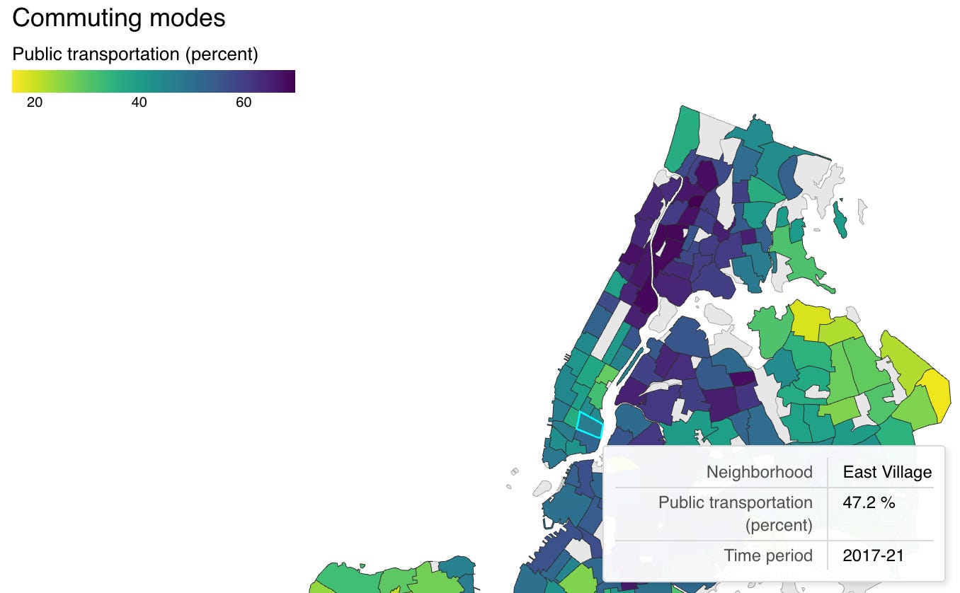
The East Village, particularly the streets surrounding Tompkins Square Park, would make an excellent pilot program candidate. Walk down East 10th Street or any other adjacent block and you’ll see why this area is primed for pedestrian-first streets. For one, car ownership rates in this neighborhood are among the lowest in all of NYC, averaging 19% for Community District 3 (CD3). Public transit utilization is also relatively high, with over half of CD3 residents using public transportation to commute and significant portions of cyclists and pedestrian commuters as well.
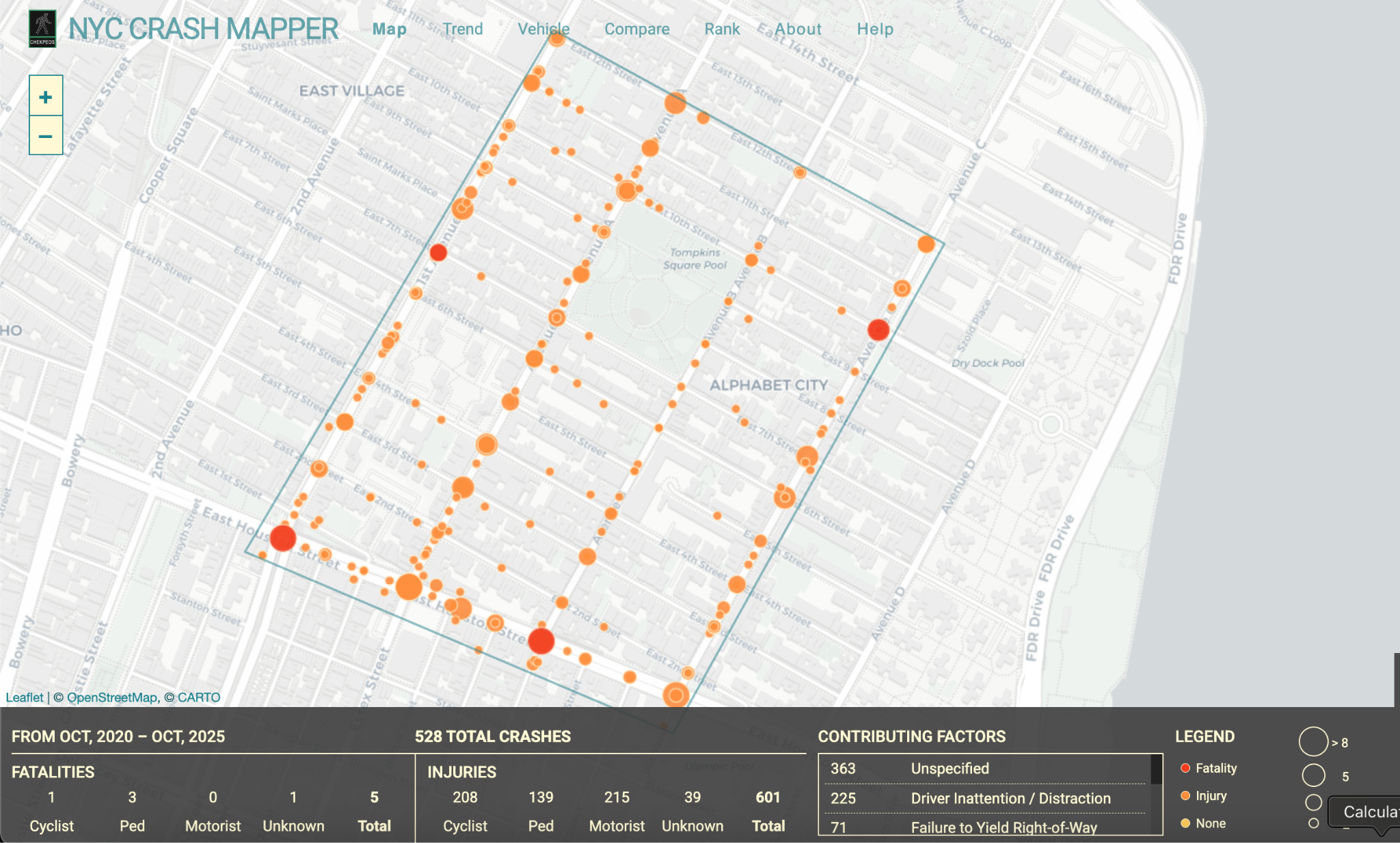
And yet, according to NYC Crash Mapper, between October 2020 and October 2025 there were 2,838 car crashes in CD3 resulting in twenty fatalities - sixteen of which were pedestrians. Dozens of these crashes occurred on the blocks surrounding Tompkins Square, and nearly all were due to driver error or unsafe driving behavior that ignored current traffic laws. Note how many of these crashes occurred on intersections off of Houston Street or on the avenues, where there exists high thru traffic volume. There are also several public schools near the park and a considerable number of families and senior citizens that would particularly benefit from safer streets.
DOT has already laid the groundwork for designing an LTN in this neighborhood as well. The currently underway Avenue B redesign proposal is capitalizing on the success of the Avenue B Open Street to permanently improve cyclist infrastructure and construct limited pedestrian plazas. As I wrote in my previous post on the redesign,
“According to the 2021 Vision Survey run by DOT, the primary use of Avenue B by residents is by far walking over motorized commuting. Residents have also shown a desire for improved pedestrian access, with 65% of survey respondents wanting the avenue to be permanently redesigned to be more pedestrian friendly…DOT Street User Count data found an average of 5x as many pedestrians trafficking Avenue B than cars at peak hours, and equal numbers of bikes as cars.”
The neighborhood’s commuter characteristics, existing DOT projects, and convenient location in the City make this section of the East Village the perfect candidate for a full LTN redesign. All that is required by DOT is to go a few steps further with its existing proposals, installing more comprehensive pedestrian-friendly structural redesign instead of the piecemeal programs currently spread across the district in the form of Open Streets and disconnected bike lanes. As DOT learns lessons from this pilot and residents experience the joys of safer and quieter streets, the Tompkins Square pilot can serve as the case study for LTN expansion across the city, returning the purpose of NYC’s streets to be for the people and not for the cars.
Next Steps
For those who would like to support Low Traffic Neighborhoods in NYC, here are some immediate steps you can take, provided by Open Plans:
Do you have a neighborhood in mind that might be a good fit for an LTN? Suggest one here!
Bring LTNs to NYC! Write a letter to your elected officials and the DOT to support Low Traffic Neighborhoods.
LTN One Pager - please share with your neighbors!!
If folks have any additional questions or are interested in bringing this to your Community Board, please reach out to [email protected] or [email protected].
Since 2021, DOT has pursued policies in accordance with its NYC Streets Plan which emphasizes the safety, accessibility, and equity of NYC’s streets.
Unlike Open Streets or anti-reckless driving, LTNs also do not require additional enforcement or labor after being constructed. This brings maintenance costs down massively compared to current programs. Combined with the health benefits and time saved from reduced traffic, LTNs can actually bring in money for the City in the long-term.
The NYC DOT has never designed a good Slow Zone. The Copenhagen City architect looked at New York's protected bike lane standard and said, "We would not do it like that in København!" All the best new streets in NYC were built by BIDs.
Will Norman, Commissioner of Walking and Cycling in London, says, "You won't see many bumpouts here. We don't like them."
The DOT has created some great Tactical Urbanism like 34th Street and Madison Square. But they are still heavy-handed. Madison Square might be the best Tactical Urbanism in the US, but it is not good long-term urbanism, and it has been there 17 years.
Today in Streetsblog: https://nyc.streetsblog.org/2025/12/08/no-better-place-mamdani-must-pedestrianize-financial-district
I think raised sidewalks would be another great tool to delineate between thoroughfare roads and LTNs. They would slow cars down and create a more drastic “line in the sand.”
I’ve been using my own moniker, Pedestrian Priority Zone, having no idea the term LTN existed. Better late than never to the party.