
NYC Mapped Its Greenways. Now It Has to Build Them.
Examining the Greater Greenways Plan, accessibility patterns, and the problem of isolated pedestrian infrastructure

Anyone who has spent time on the Hudson River Greenway, on Manhattan’s west side waterfront, knows how incredible the greenway experience in NYC can be. Lush vegetation alternating with modern urban parks and playgrounds, revitalized piers and well-preserved 19th-century ornamentation, all with unbeatable views of the Hudson River and NYC’s tallest skyscrapers.
As a former resident of the Upper West Side, the Hudson River Greenway (HRG) and Riverside Park, with its wide pedestrian boulevards and grand historical statues, were the prize of the neighborhood. When Lower Manhattan and Brooklyn friends would nudge me to move downtown, I would hesitate solely on losing proximity to this premier green space.


That’s because, as great as Manhattan’s west side greenway is, much of the pedestrian infrastructure in the rest of the City is lacking. The beauty and impressive length of the HRG stands out against the disconnected and inadequate greenways in most other parts of NYC. Just head over several avenues east and notice how lacking and uninspired the east side’s “greenway” is by comparison.
From my post on the new East River Park:
Take the pedestrian path on the East Side below Waterside Pier, which requires being squeezed between a busy roadway and parking lots under the FDR highway, down an extremely narrow path (so narrow, in fact, that most pedestrians choose instead to cross through the neighboring parking lot), through a sometimes locked and narrow path of the Waterside Towers, and down an access road before meeting up with the recently opened bike lanes and Stuyvesant Cove Park. This entire Midtown segment lacks any sort of green space, provides extremely limited access for pedestrians, and certainly has no provisions for other uses of the waterfront, like events or gatherings.

NYC can and should do more to improve its greenways citywide and better connect the parks throughout the rest of the city. Better parks and pedestrian infrastructure lead to healthier and happier lifestyles, reduced traffic congestion, reduced crime, and myriad economic benefits.
The Greater Greenways Plan announced by a coalition of city agencies in 2025 is an excellent first step in providing necessary green infrastructure for the City’s residents. It will be the mission of this new mayoral administration to turn its ambitious suggestions into reality.
Let’s go over the plan, explore the data on how expanding greenways benefits NYC, and talk about what steps the City should take next to act on its plan.
What is the Greater Greenways Plan?
“New York City’s greenway system, developed by multiple agencies and partners, has grown over time, often in fragmented segments. To address this, and in accordance with Local Law 115 of 2022, the City has completed a two-year effort to inventory, map, and analyze the entire greenway network.”
- Executive Summary section of the NYC Greenway Plan
The Greater Greenways Plan (GGP) catalogs the current state of NYC’s greenways and outlines a loose plan over the next four years to expand and connect this system. Greenways are defined in the plan as “continuous, multi-use corridors designed for human-powered and electric-assist transportation and recreation.” Because of this expansive definition, and interspersed pedestrianization efforts over preceding decades, GGP claims over 500 miles of existing greenway in NYC, with 378 of those miles being protected greenways (separated from traffic, rather than a bike lane that may be sharing a lane on the road with cars, for example).
The plan is full of interesting design principles and snippets of the impressive variety of greenways throughout the City. It also properly emphasizes the many, many benefits of greenways. These include:
Environmental: improve air quality, provide tree canopy for shade, impervious ground cover for stormwater retention, resilient vegetation for beautification, and preservation of open space and wildlife habitats for future generations
Health: encourage walking and cycling, fostering communities and promote social cohesiveness, community connections, and cultural awareness; improve health outcomes for heart disease, diabetes, cancer, and other chronic diseases; improve mental health and decrease risk of psychiatric disorders in adults and youth
Recreation: connect neighborhoods historically lacking parkland, increased space within communities dedicated to active recreation
Transportation: enhance affordable and accessible transportation options that accommodate various users (pedestrians, analog cyclists, and micromobility users) of various abilities; connect communities with limited access to public transportation and/or low car ownership rates to job centers, business districts, and neighborhood amenities; provide continuous, long-distance routes often off-street or separated from motor vehicular traffic, reducing conflicts between pedestrians, motor vehicle operators, and cyclists
Economic: benefits to properties and more local investment, new connections to job hubs and commercial districts, provide sustainable transportation to several working waterfronts, and increase tourism by offering a pedestrian-friendly city
That is quite the list. It’s clear that residents, visitors, businesses, and the City itself can greatly benefit from expanding greenways in every borough. Similar to how public transit is most useful when connecting living and working hubs, greenways are most useful when connecting parks and waterfronts. The biggest issue preventing full utilization of the many miles of existing greenways is that many of them are isolated and disconnected from the larger network.
Shortcomings of NYC’s Existing Greenway Network
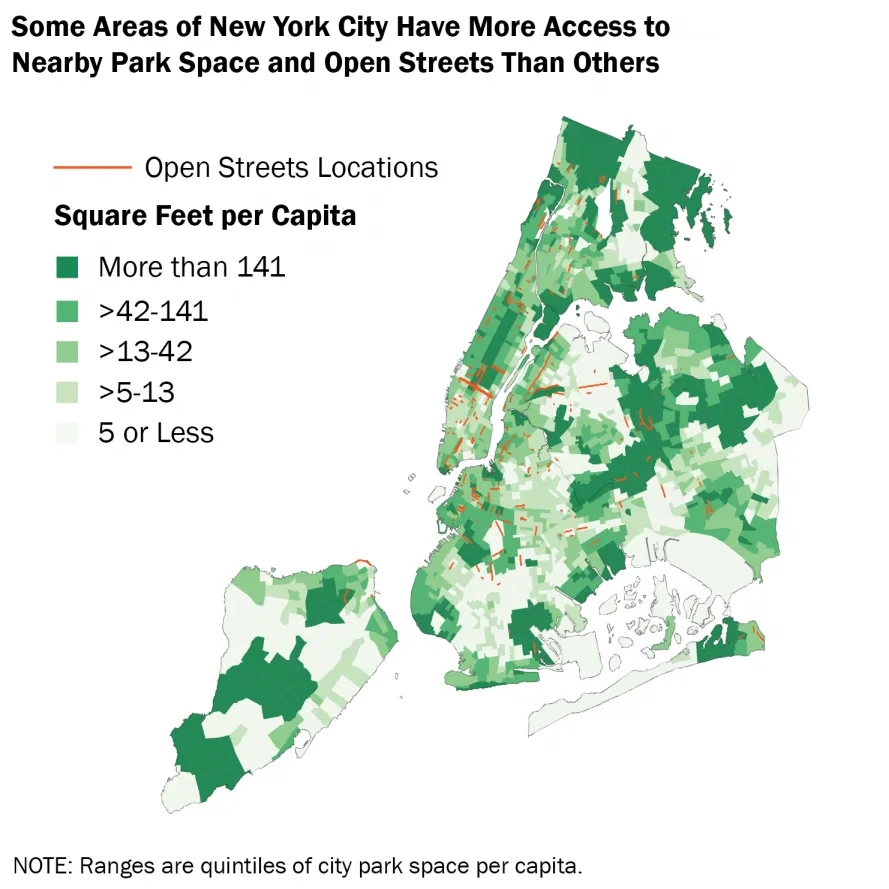
GGP acknowledges that greenways are mostly valuable when forming a continuous route that connects to each other and to community amenities such as parks and waterfront. An isolated biking path spanning a couple of streets will be little used if it requires crossing dangerous roads to reach, just as a waterfront park cut off by a highway becomes inaccessible to the surrounding communities.
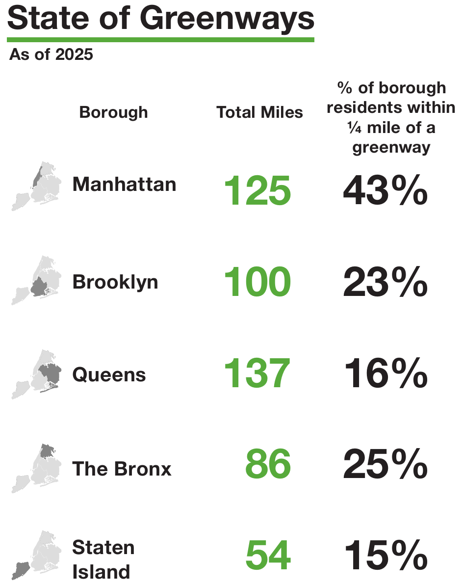
At the time of the report’s publication, the vast majority of residents did not live near a greenway, and only 17 miles of new greenway were actively under construction. Outside of Manhattan, less than a quarter of residents live within 1/4th of a mile of a greenway - making access particularly lacking in lower-income neighborhoods that would most benefit from greenway amenities.
Part of the blame for this is that the City did not actually have a comprehensive, detailed view of its existing network. The two-year analysis leading to the GGP report addressed this first barrier. Another issue is that jurisdiction over greenways is divided between the NYC Department of Transportation (DOT), NYC Parks, and “a mix of government agencies, public authorities, and private landowners”. Cross-agency coordination, a timeline for identifying and prioritizing specific projects, and additional funding were needed.
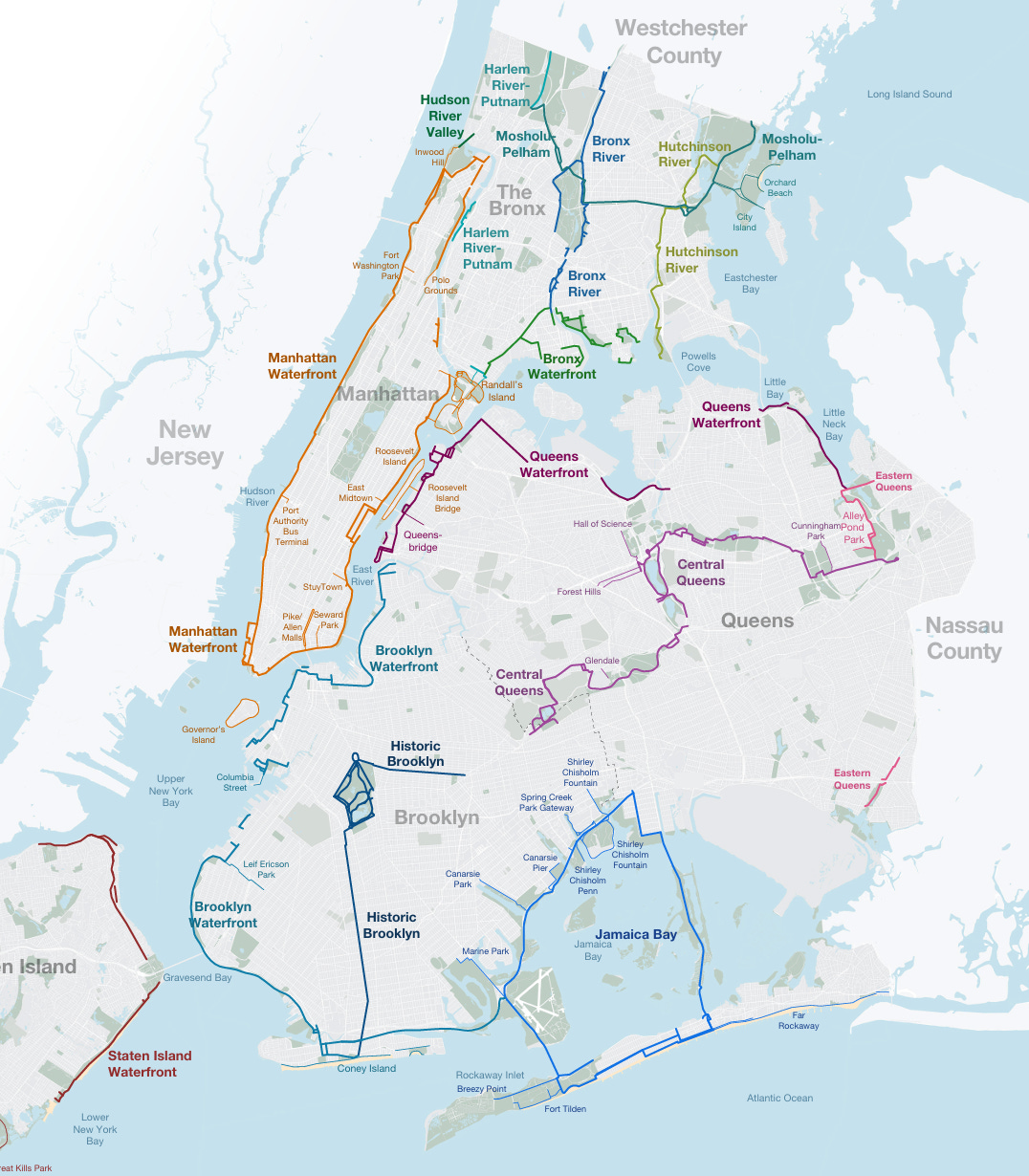
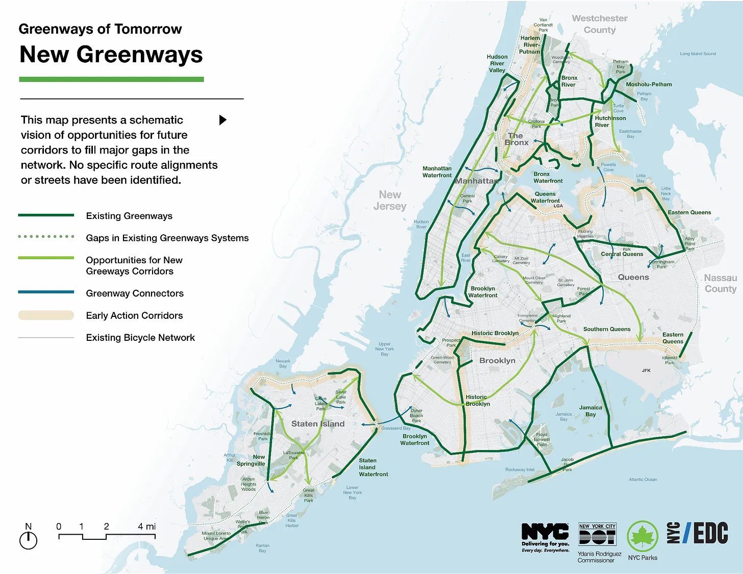
The “Greenways of Tomorrow” portion of the plan addresses some of these needs. GGP proposes to expand the greenways network and connect the isolated systems by evaluating the progress of past projects, identifying existing gaps, setting priorities, and outlining implementation strategies. Such work has already begun with a $7.25 million federal grant awarded to NYC in 2022, which is being used to construct 40 miles of new greenways by 2028, identified as “Early Action Corridors” in the image below.
With the GGP, the City has done an excellent job of mapping out the existing greenways network and identifying the most notable gaps. The Early Action Corridors are an exciting initial effort to begin closing these gaps. But for the dream of a comprehensive, connected network that turns the potential health, transportation, and economic benefits into reality, concrete plans and timelines on a larger scale, backed by much greater funding, will be necessary.
How NYC Can Implement GGP and Do More For Its Greenways
The City’s plan repeatedly mentions the need to coordinate across agencies to forge a path for the vision laid out in the GGP, without actually describing how this will be done or what the next steps are exactly. While the rhetoric is encouraging, details are missing, and it’s not clear how the more ambitious opportunities for new corridors will be implemented.
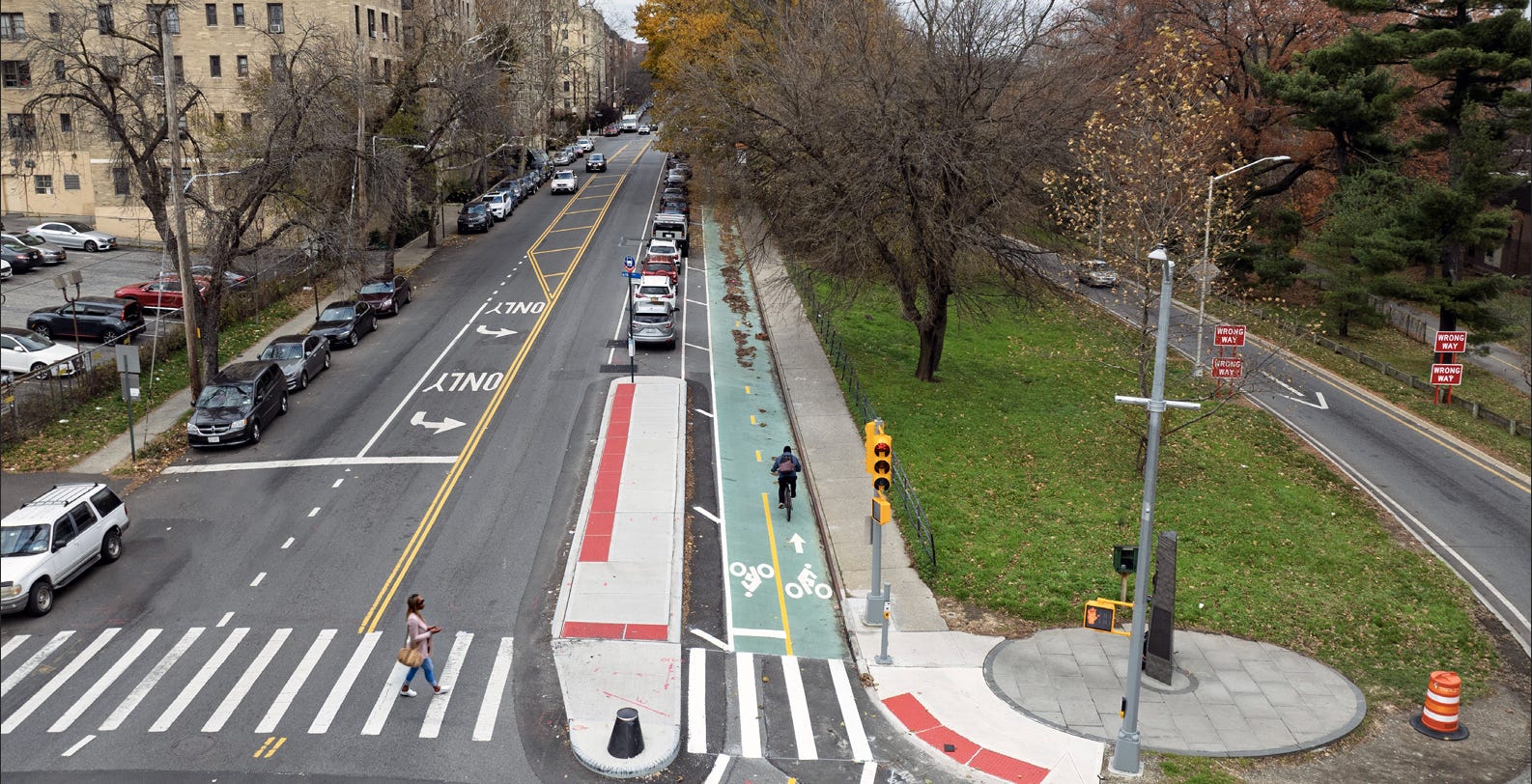
Further, many of the existing greenway miles have either fallen into disrepair or are little more than paint on the road, without actual separation from or protection from vehicular traffic (nor containing much greenery). A greenway that involves dodging cars at intersections, sharing the same lane with traffic on busy roads, or managing numerous potholes and broken sidewalks will not be fully utilized by commuters or attract tourists. If the City cannot even maintain its current greenway network, that does not offer much hope that it will successfully expand it in the near future.
To NYC’s credit, it has committed over $1.3 billion to “close the loop” and connect all segments of the Manhattan waterfront greenways. Funding on this scale will be necessary to fully connect greenway sections in the other boroughs and to develop the new greenway corridors recommended in the GGP. If the Mamdani administration is serious about improving the quality of life for New Yorkers, it should include additional funds for greenway development in the other boroughs in its upcoming proposed fiscal budget. That means increasing the budget for both NYC DOT and Parks, which manage the largest portions of the system.
NYC DOT Commissioner Mike Flynn, newly appointed by Mayor Mamdani earlier this month, has been tasked by the Mayor to make NYC’s streetscape “the envy of the world”. While his background provides hope that he will follow through, similar claims were made by previous DOT Commissioner Ydannis Rodriguez. Instead, his DOT repeatedly fell behind on mandates for new miles of protected bike lanes. Commissioner Flynn should prove he won’t also mislead voters by prioritizing greenway development and constructing the connector segments proposed in the GGP while improving the state of decrepit existing greenways immediately.
A vision has been laid out by the GGP. It’s now up to this new administration to make it into a reality. NYC has the potential to be a premiere city for walking, biking, and traveling around without relying on a vehicle. The pieces are all there for a City ready to turn ideas into actions. But without specific timelines, funding, and accountability, the GGP risks becoming a beautifully designed map, and nothing more.
The Mayor and DOT Commissioner should prove they are serious allies of pedestrians by outlining a specific timeline for greenway development and providing the funding necessary to actually build the proposed segments.
"Manhattan Waterfront" usually means "Manhattan below 96th St". Inwood has almost no greenway infrastructure and what it does have is absolutely terrible. The simplest and fastest thing that NYC could do is take a lane from the HHP northbound and HRD northbound and -- presto -- much better greenway connectivity for Upper Manhattan. This could be done within a week by simply sliding over existing barriers, it's that easy.
https://docs.google.com/presentation/d/17MELlB3FpxvVcRFLllZJ5E-wl0HoxnD2IUfHSaeYQkA/edit?usp=sharing
I’d seen the map and was suspicious of what seemed like an over representation, but good to know it was just a loose definition. Shows the importance of the definition.