
A New East River Park for a Greener Manhattan
How the East Side Coastal Resiliency Project is providing much-needed needed greenspace to Manhattan’s most neglected waterfront

As part of my goal to shine a light not only on areas of improvement for local governance but also on the many success stories, I would like to highlight a recent public infrastructure project underway in Manhattan’s Lower East Side: the new East River Park openings and ongoing East Side Coastal Resiliency Project renovations.
On a recent Saturday morning, I had the pleasure of jogging from my apartment in the LES down to Delancey Street, where I then followed the street underneath the Williamsburg Bridge to the current only access to the new East River Park (a second bridge access has since opened). This new section of the East River Park had officially opened on May 28, 2025, but this was my first time entering it.

Two observations immediately struck me:
How much better looking this park was than most of the surrounding area and the rest of the Lower East Side waterfront area, and
How busy and alive the park felt, even on an early weekend morning - when the LES tends to be quiet, many residents still asleep from their late-night outings
The Deplorable State of Manhattan’s East Side Parks
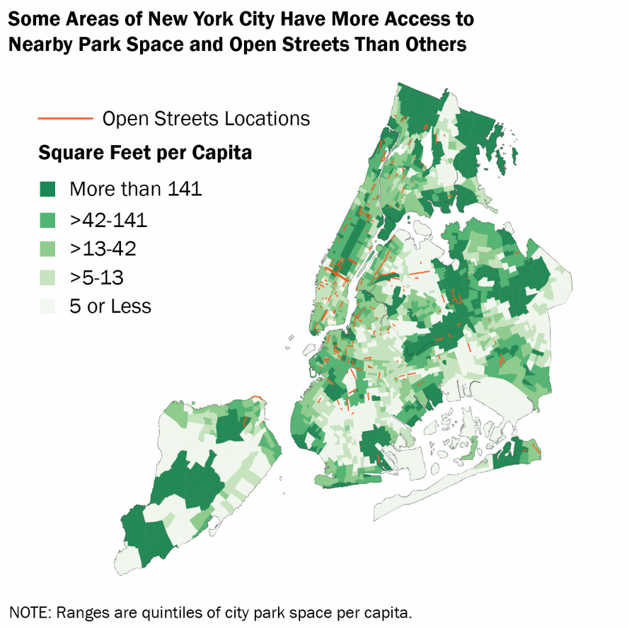
Together, these two observations are telling of how much pent-up demand there is for improved green space in the LES, and that the newly opened section of the (officially titled) John V. Lindsay East River Park is going to be an excellent step toward answering that demand. In fact, looking at a map of Manhattan’s park space by neighborhood, we see a decisive lack of such in the southeast of the borough. In particular, the LES lacks continuous green spaces akin to Riverside Park in the west, Morningside Park and Carl Schurz Park in the north, and most famously Central Park in the center. While the neighborhood is dotted with community gardens and has some notable urban parks like Tompkins Square and the renovated Pier 42, these do not provide the same natural respite as the larger parks. The crowdedness, noise, and relative lack of trees and other natural features result in the parks feeling more like urban plazas than true green spaces. And while they are great and necessary for every neighborhood, access to truly green spaces is equally important.
These facts are borne out by the data, too. Looking at the Trust for Public Land’s parks map, it is clear how much better park access is on Manhattan’s West Side compared to its East Side. West Side neighborhoods on the same streets as those in the LES, but several avenues over, enjoy park acres per person typically around 0.1 to 0.3. The East Side equivalent blocks fall mostly into the 0.03 to 0.1 range - and this is counting the East River parks that have been mostly closed for renovations over the past several years.
Similarly frustrating is the state of Manhattan’s East Side waterfront compared to the beauty and accessibility of the West Side and Northern Manhattan parks. While the West Side provides continuous pedestrian and bike paths from the Battery to Inwood Hill, with these paths especially surrounded by lush greenery and trees from 72nd Street up, the East Side doesn’t even come close. Recent improvements of Waterside Pier and Stuyvesant Cove Park, and longer-existing pedestrian paths like those extending out from Carl Schurz Park, provide small segments of waterfront accessibility. But there are no connections between these alcoves, and some of the existing segments leave much to be desired.
A walk down both waterfronts will quickly reveal contrasts in design and utilization. Take the pedestrian path on the East Side below Waterside Pier, which requires being squeezed between a busy roadway and parking lots under the FDR highway, down an extremely narrow path (so narrow, in fact, that most pedestrians choose instead to cross through the neighboring parking lot), through a sometimes locked and narrow path of the Waterside Towers, and down an access road before meeting up with the recently opened bike lanes and Stuyvesant Cove Park. This entire Midtown segment lacks any sort of green space, provides extremely limited access for pedestrians, and certainly has no provisions for other uses of the waterfront, like events or gatherings.
A Beacon of Hope
Enter the new East River Park section south of Houston Street, a green oasis providing a stark contrast with the busy highway and dense urban blocks situated right next door. Rolling hills, spaces for soccer and tennis and barbequing, with a bike path weaving throughout and benches and lawns interspersed throughout. Being in this park for just a few minutes, you almost forget you’re next door to one of New York’s most dense and least tree-filled neighborhoods.
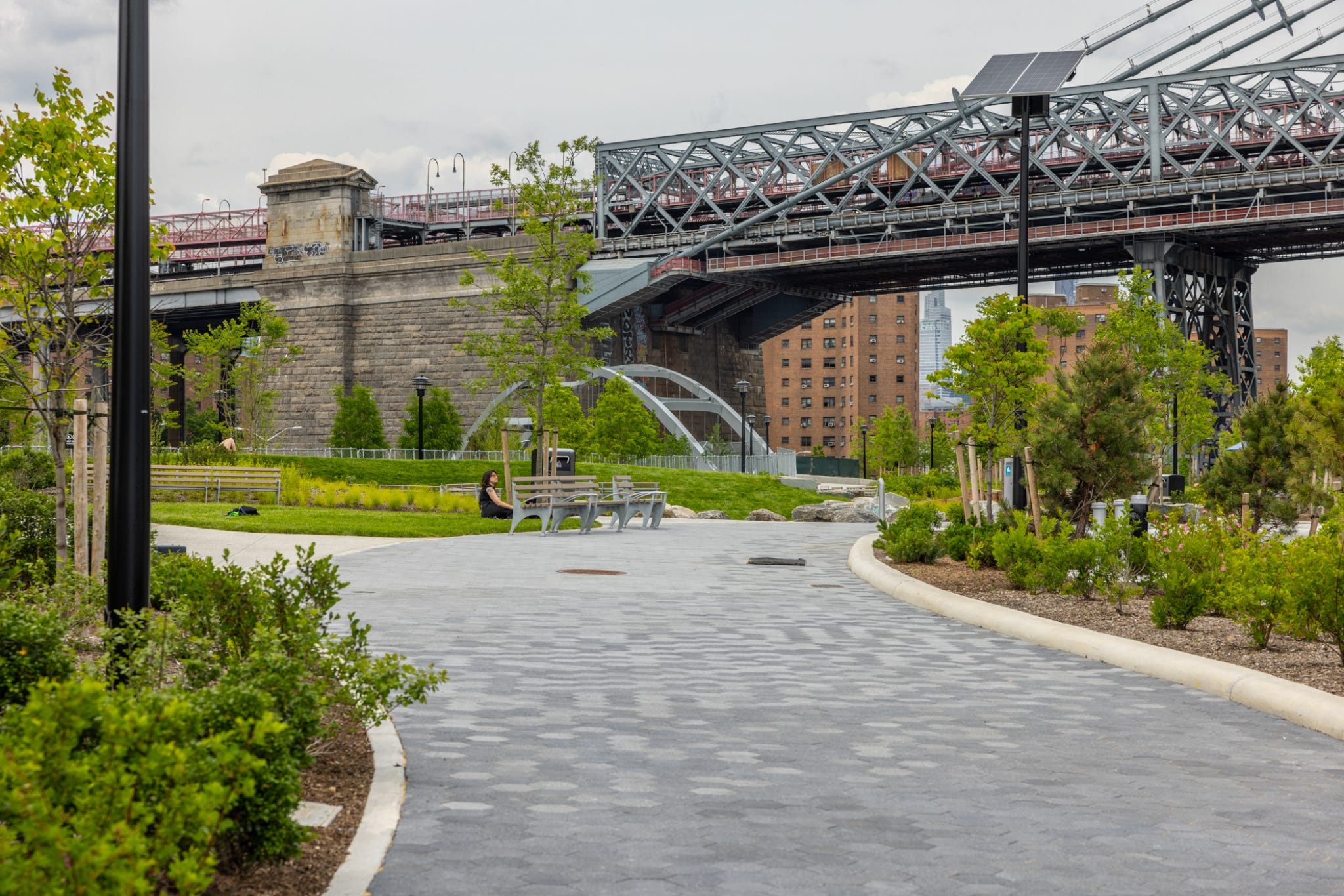
The park redesign is part of the larger East Side Coastal Resilliency (ESCR) Project, a massive $1.45 billion project lifting the entire East Side of Manhattan 8-10 feet higher, to prevent the type of flooding disaster that occurred in the wake of Hurricane Sandy in 2012. Seizing the opportunity to not only protect the City from rising sea levels and storm damage brought on by climate change, the raised sections of Manhattan’s coastline are featuring some of its best new green spaces. Just this one section below Houston St, of several new waterfront parks, contains: six regulation tennis courts, two regulation basketball courts, picnic and BBQ areas, a nature exploration area, a passive lawn and a multiuse area, 600 new trees, and more than 21,000 new shrubs, grasses and perennials. Of course, many of these newly planted trees will take years to grow to a size where they provide adequate shade for visitors, but it’s encouraging to see their presence at all compared to the barren concrete and asphalt typical of the area.
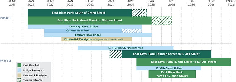
The 3.2 miles of revitalized coastline along the East River is one component of the ESCR, the key feature being a flexible 2.4-mile-long flood barrier on the Lower East Side from Montgomery Street up to East 25th Street. Construction on this project began in late 2021 and will continue until at least 2027, with many sections of the flood barrier already present on the east side waterfront. Besides the flood walls, additional flooding protection for the LES will be provided through raised parkland, berms, 18 swinging or sliding flood gates, and an upgrade of existing sewer systems to capture and manage precipitation during storms.
What Comes Next?
The new East River Park section is a gem added to Manhattan’s prestigious collection of park space, and the forthcoming opening of a section connecting the current space to Corlears Hook Park will be a great extension1. Once the rest of the ESCR renovations are complete, the LES will boast of a revamped and connected greenway waterfront extending from Montgomery Street all the way up the E 25th Street.
Bjarke Ingels, one of the lead designers for the new East River parks, commented on the thinking for these new park sections,
“Each island of green is devoted to a use and character decided by the community. Rather than separating the city from the waterfront, we’ve designed a public realm that invites people in with new connections across the FDR…”
This statement is revealing in how the waterfront has typically been looked at on Manhattan’s east side: separate from the city and wholly uninviting to the public. While historically the waterfront was the territory of industry and shipping, unattractive for living or leisure, such has not been the case in NYC for many decades. With manufacturing and factories long having left the City, work must continue to convert abandoned factories and decrepit piers into livable space. The recent conversion of the Domino Sugar Factory in Williamsburg and the proposals for Brooklyn Marine Terminal represent other case studies for adapting NYC for the 21st century and building parks and housing on the shells of these abandoned industries.
The four new bridges providing access from the Lower East Side to these new parks are one small step in improving waterfront accessibility. More will have to be done to undo the damage of having FDR Drive divide residents from the parks on the river. For one, access to the parks and overall waterfront is still way too limited, and four bridges are not enough for the hundreds of thousands of residents. The proximity of FDR Drive to the park and the lack of any real separation between the park and the road make the noise pollution from the endless stream of cars pervasive in some sections. Mostly, however, this new recreational oasis is highlighted by its current isolation from any other park spaces or greenways north of the park.
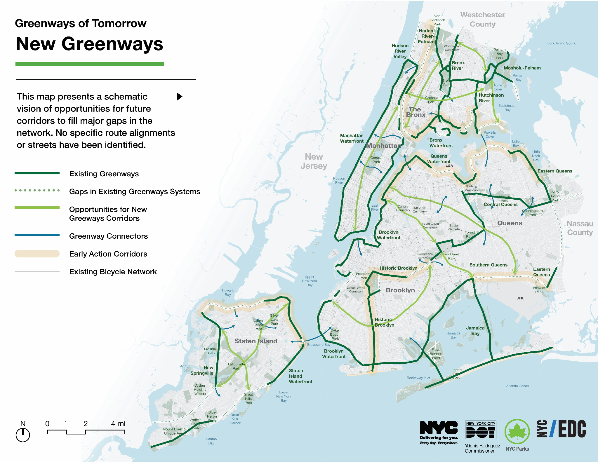
My hope is for such expansion of park space to continue, both as part of the ongoing ESCR renovations and as purposeful green space expansion efforts by the City. Last month, a coalition of agencies released a “Greater Greenways” plan, announcing their intention to expand the network of existing greenways in NYC with a focus on creating more continuously connected corridors. The plan includes 40 new miles of greenways being built starting in 2028, though actual details regarding timelines are scant. Also worryingly, their map claims the entire east side from the Battery to around 125th Street to already be a connected greenway - certainly not the experience of anyone using them today2. I encourage these agencies to take a closer look at the current “greenway” sections between East 25th Street and East 34th Street and seriously consider improving the pedestrian thoroughfare and foliage in that area.
But the announcement presents the right mindset and gives hope for the continuing connection and growth of parks throughout the five boroughs. The new East River Park shows that the City can make beautiful and livable spaces anywhere, especially in neighborhoods damaged by storms or left behind by abandoned industries. As the ESCR project rumbles on and new parks open north of Houston Street, residents of the LES will enjoy not only heightened climate resilience but also unprecedented opportunities for recreation, leisure, and community gatherings.
It also helps to offset the loss of the East River track, which closes next week for its own stage of the ESCR Project and may not be reopened until Spring 2028 at the earliest.
I absolutely support the goals of the Greater Greenways plan and advocate for the expansion of our greenways network, but I also believe there is much room to improve the existing greenways of today. Forcing pedestrians to use parking lots and narrow, semi-private walkways is a poor excuse for a greenway and discourages usage. The City should not only maximize the mileage of greenways but maintain a high level of quality among that mileage, with safety and usability held to a minimum standard throughout those spaces.
Did you ever visit any of the parks along the East River before this trip? They were very green, filled with trees, and had plenty of public use space (including the amphitheater) before this "renovation". This is a very weird take.